Our Earth Networks Meteorologists revealed their 2021-22 Winter Forecast during our Winter Outlook Webinar on November 10, 2021. Keep reading to watch the recording and learn what to expect this winter!
The winter weather outlook is an important one, as it helps us prepare for oncoming cold weather during the three coldest winter months of the year, and into the spring. What temperatures and precipitation trends will the United States experience this winter season?
In this blog post we will go over the main points from the 2021-22 Winter Outlook, as well as a recording of the webinar.
You can also download the slides and go through them on your own.

Winter Outlook Overview
This year, the winter forecast largely follows the trends seen with a typical La Niña and negative Pacific Decadal Oscillation. Earth Networks meteorologists are forecasting a tale of two winters with colder than normal temperatures in the north and warmer temperatures stretching from the southern tier to the Mid-Atlantic.
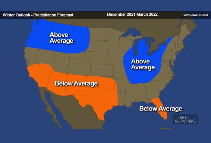
With heavy influence from La Niña, below average rainfall is forecast across much of the Southern Tier, while an active Pacific storm track should bring increased moisture to the Pacific Northwest and Northern Rockies with more rain and snow. An active storm track over the Mississippi and Ohio River Valleys could also lead to enhanced precipitation across the Midwest, Great Lakes and along the Appalachian Mountains.
Later in the winter season, La Niña increases the chance for severe weather between the Southern Plains and Gulf Coast as spring draws closer.
Winter Outlook Leading Factors
During the webinar, Earth Networks Winter Outlook meteorology team indicated that there are four main drivers of this year’s winter weather forecast. Here’s what they are and how much they factored into their forecast:
- El Niño-Southern Oscillation (ENSO) 40%
- Analog Winters 30%
- Decadal Trends (Temperature & Precipitation) 20%
- Quasi-Biennial Oscillation (QBO) 10%
ENSO
What is ENSO?
Have you ever heard a meteorologist say the term “ENSO,” or the phrase “El Niño Southern Oscillation,” and wonder what they were talking about?
ENSO is periodic, cyclical warming or cooling of the equator with all the crazy weather. El Niño is the warming cycle and La Niña is the cooling cycle.
What does ENSO have to do with the Winter Outlook?
It all has to do with the temperatures. We know winter gets cold, but how cold it gets has a lot to do with what phase of El Niño we’re in.
Will it be an El Niño, La Niña, or Neutral winter?
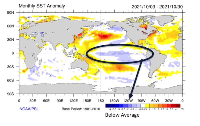
You may be wondering, which phase of ENSO is expected this winter and why? This winter our meteorologists are expecting La Niña to dominate. In essence, the equatorial Pacific sea surface temperatures are expected to be below average.
La Niña Winters
You can expect three main things when you have a La Niña winter. Below we outline some of the typical weather that La Niña impacts.
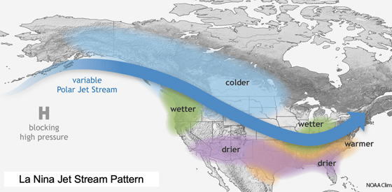
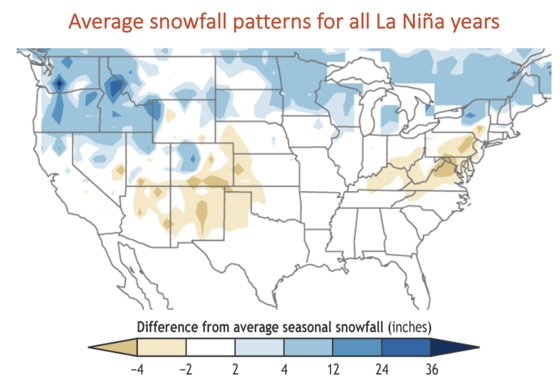
1. The typical La Niña snowfall pattern includes more snow than average in the Northwest, northern Rockies and Upper Mississippi Valley to interior New England. Concurrently, there is less snow than average in the southern Rockies, Southwest mountains, Ohio Valley and Mid-Atlantic.
2. The second thing you can expect is dry and warm weather for much of the South. If you take a look at the map above, you’ll see that La Niña winters typically bring the warmer weather from Texas through the East Coast.
3. The third and final thing you can expect from a La Niña is wetter weather in the Ohio Valley area. It will be dry and warm in the southern tier and East Coast, while wet in the Ohio Valley.
Snowfall During La Niña Winters
A combination of short-lived cold blasts and an active storm track will produce below-average temperatures across the northern tier and as far south as the central Rockies and central Plains.
Cold blasts will be transient from the southern Plains to southeast New England coast, leading to warmer than average temperatures for the winter season.
Cold blasts and warm spells will balance out to near average temperatures for California, the Southwest, southern Rockies, central Plains, Midwest, Upper Ohio Valley and much of the Northeast.
2021-2022 Winter Precipitation
La Niña also impacts a winter season’s precipitation. We can anticipate a lot of precipitation this winter season, with above average precipitation in the Northwest and Northeast regions.
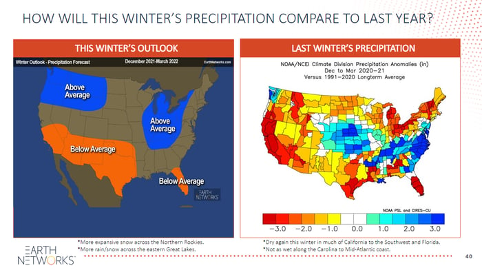
Take a look at the webinar recording to learn more about how this winter’s expected precipitation patterns compare to last year.
Decadal Trends
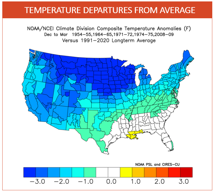
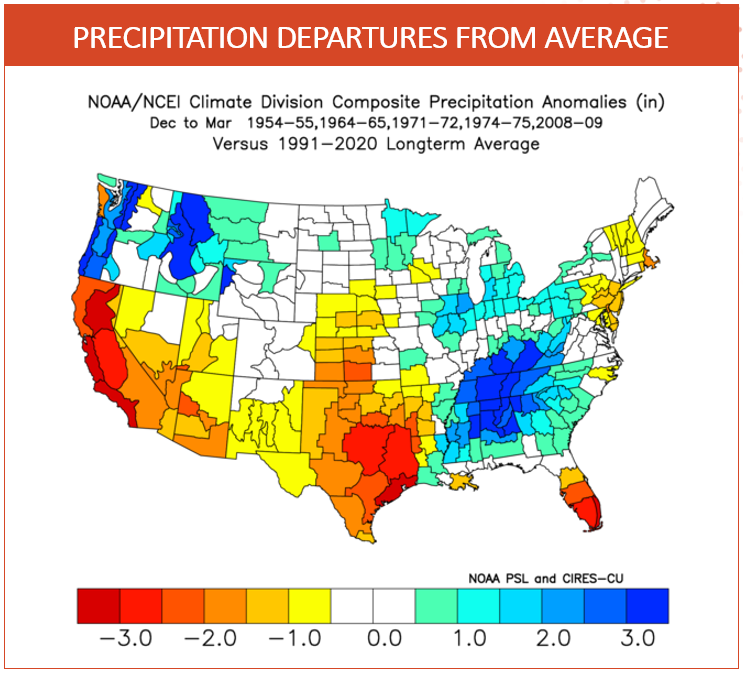
In our webinar, we looked at data from the last 10 winters across the U.S. to help us get a better idea of what this winter might look like. As you can see from the Temperature Department from Average map below, most areas in the U.S. have been warmer than normal throughout the winter months.
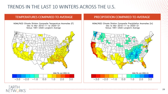
These decadal trends provide noteworthy insight into winter temperature and precipitation trends.
The Earth Networks 2021-2022 Winter Outlook
What to Expect this Winter
This year’s Earth Network winter forecast favors a typical La Niña pattern and a negative Pacific Decadal Oscillation (PDO), with increased chances of the following:
- Below-Average temperatures for the northern tier: a combination of short-lived cold blasts and an active storm track will produce below-average temperatures across the northern tier and as far south as the central Rockies and central Plains.
- Variable Temperatures between California, the Heartland and Northeast: cold blasts and warm spells will balance out to near average temperatures for California, the Southwest, southern Rockies, central Plains, Midwest, Upper Ohio Valley and much of the Northeast.
- Above normal temperatures from the Southern Plains to the Southeast: cold blasts will be transient from the southern Plains to Southeast and Mid-Atlantic coast, leading to warmer than average temperatures for the winter season.
- Increased rain and snow for the Northwest and Mountain West: with colder temperatures and an active Pacific storm track, ample snow is in the forecast for the Cascades and Northern Rockies which will be beneficial to the upcoming ski and snowboarding season.
- Drought Persists in the Southwest: with the bulk of Pacific moisture remaining north of the Southwest, less rain and mountain snow will continue harsh drought conditions that have plagued the region over the last few years. Drought may develop across parts of Texas and Florida as the favored storm track will promote dry weather along the southern tier.
- Active storm track expected across the Tennessee Valley to eastern Great Lakes; could result in more rain and snow than average, and increased lake-effect snow. The active storm track driven by the polar jet stream could also increase the chance for severe weather across parts of the Southern Plains and Southeast.
Watch Our Winter Forecast Webinar
Want to watch the entire Winter Outlook Webinar? Check it out below! The webinar recording is free to watch, and you can even download the slide deck if you’d like to go through it at your own pace.
Common Winter Weather Threats
Freshly fallen snow and crystal clear icicles are beautiful sights, but don’t let that fool you. While beautiful, winter weather is also downright dangerous.
Now that you know what to expect this year, the next step is refreshing your winter weather safety. If you don’t have commercial weather tools at your organization that help you manage winter weather threats, click the link below to get in touch with one of our experts who will help you build a comprehensive plan.
Snowstorms and extreme cold are two of the most dangerous forms of winter weather.

Some of the most common winter weather threats include:
- Car accidents
- Hypothermia
- Frostbite
- Carbon monoxide poisoning
- Heart attacks (from overexertion while shoveling)
Learn more about the most common winter weather risks and how to protect yourself on our blog.
Winter Weather Safety Tips
You can get ready to face winter weather threats with these winter safety tips:
- Stay off roads
- Stay indoors
- Dress warmly
- Prepare for power outages
- Use generators only outside and away from windows
- Listen for emergency information and alerts
- Look for signs of hypothermia and frostbite
- Check on neighbors and coworkers
More Seasonal Outlooks
Here at Earth Networks, our meteorologists love to put together seasonal outlook webinars to help everyone – not just our customers – plan for the weather.
We’re committed to helping our friends at the National Weather Service (NWS) build a Weather-Ready Nation , and believe these webinars are a great way to make sure everyone in the U.S. knows what to expect.
Besides the Winter Outlook Webinar, we give other important forecast presentations throughout the year, including:
🌀Tropical Outlook
🌪️Spring Outlook
☀️Summer Outlook