UPDATED By Earth Networks Meteorologists: Andrew Rosenthal and James West
Hurricane Irma September 8 Update
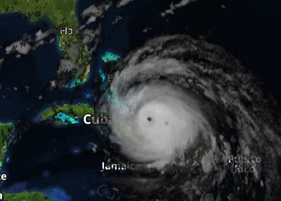
Hurricane Irma remains a Category 4 major hurricane as it moves between the central Bahamas and Cuba’s northern coast. Floridians need to finish preparations today for Irma’s weekend landfall.
Location
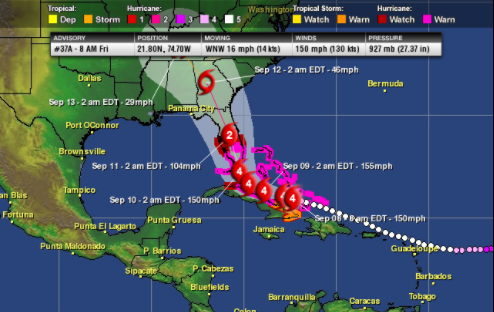
As of 8 a.m. EDT (AST), Hurricane Irma was located near 21.8 N and 74.7 W. That's 80 miles northeast of Cabo Lucrecia, Cuba and 450 miles southeast of Miami. It continues to move west-northwest at 16 mph.
Strength & Pressure
Irma’s top sustained winds have dropped to 150 mph. After being a Category 5 for an impressive amount of time, Irma is now a potent Category 4 hurricane on the Saffir-Simpson Hurricane Wind Scale. Irma’s minimum central pressure is 927 mb, or 27.37 inches of mercury.
Warm water along Irma’s path will allow it to maintain its major hurricane intensity. Some fluctuation in strength is possible. A hurricane this intense can lead to catastrophic damage along its path. It has already destroyed almost every single house on the island of Barbuda in the Leeward Islands. It has also killed at least two people in the U.S. Virgin Islands.
Timing
A strong Atlantic high pressure positioned to the north of Irma continues to guide it west. Irma will next approach and pass through the southern Bahamas and near northern Cuba today. It will bring destructive winds, flooding rainfall, and storm surge to these areas.
Irma will then turn north and impact Florida and the western Bahamas on Saturday and Sunday. After that, it will slide through the interior Sunshine State and northward into Georgia
Irma Hurricane Warnings
Hurricane Warnings stretch across southern Florida and parts of the Caribbean. This includes:
- The Florida Keys
- Lake Okeechobee
- Florida Bay
- From Jupiter Inlet southward around the Florida Peninsula to Bonita Beach.
- The Bahamas
- The Turks and Caicos Islands
- The Cuban Provinces of
- Camaguey
- Ciego de Avila
- Sancti Spiritus
- Villa Clara
Hurricane Watches are in effect for the following areas:
- North of Jupiter Inlet, Fla., to Sebastian Inlet, Fla.
- North of Bonita Beach, Fla., to Anna Maria Island, Fla.
- The Cuban provinces of
- Guantanamo
- Holguin
- Las Tunas
- Matanzas
Tropical Storm Warnings are in for the Cuban provinces of Guantanamo, Holguin, Las Tunas and Matanzas. Storm Surge Watches and Warnings have also been issued across southern Florida.
Preparations and State of Emergency
The first areas to execute hurricane plans should be southern, central and northeastern Florida. Residents should prepare hurricane survival kits, install hurricane shutters, as well as evacuate if ordered.
The government already issued mandatory evacuations in the Florida Keys and coastal areas of southeastern Florida. Please heed the advice of local officials. Don’t wait to evacuate if ordered, because escape routes are already becoming gridlocked.
The governors of Georgia and South Carolina have declared states of emergency ahead of the approaching storm. An evacuation has been ordered in Savannah, Ga. Those along the Southeast coast, including Georgia and South Carolina should begin reviewing evacuation routes and safety plans.