Tropical Storm Harvey
UPDATE: Hurricane Harvey
Harvey is officially a Category 1 hurricane as of 8/24.
[video width="1280" height="720" mp4="https://www.earthnetworks.com/wp-content/uploads/2017/08/harvey.mp4" loop="true" autoplay="true"][/video]
Harvey is continuing to rapidly intensify and could make landfall along the Texas Gulf Coast as a major hurricane with winds in excess of 111 mph. Life-threatening inland flooding and storm surge is a major risk.
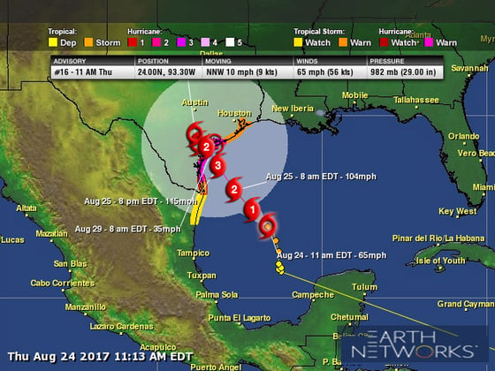
As of 10 am CDT, Tropical Storm Harvey was located near 24.0 N and 93.3 W, or about 365 miles southeast of Corpus Christi, Texas. That is also 360 miles south-southeast of Port O'Connor, Texas. Harvey's top sustained winds are now 65 mph. The tropical storm system is currently moving north-northwest at 10 mph. Its minimum central pressure is 982 mb, or 29.00 inches of mercury.
A Hurricane Warning has been issued for the Texas coast from Port Mansfield to Matagorda and a Hurricane Watch remains in effect south of Port Mansfield, Texas, to the mouth of the Rio Grande River. Tropical Storm Warnings spread from north of Matagorda, Texas, to High Island, Texas, and south of Port Mansfield, Texas, to the mouth of the Rio Grande River and a Tropical Storm Watch is in effect south of the mouth of the Rio Grande River in Texas to Boca de Catan, Mexico.
Timing
Harvey is becoming better organized this morning and rapid intensification is likely today and Friday as it moves across the very warm waters of the western Gulf of Mexico. By Friday, the upper-level environment will become more favorable for faster strengthening, and upon its approach toward the Texas Gulf Coast, it will likely be a major hurricane with top sustained winds exceeding 111 mph.
Rainfall
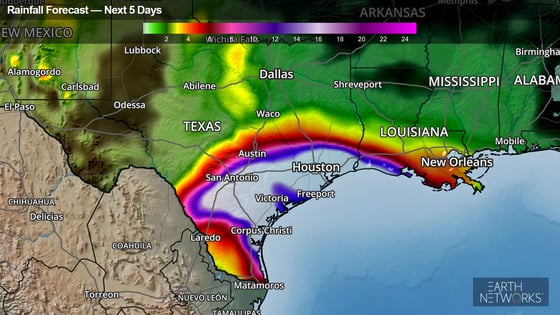
Harvey could produce 12-20 inches of rainfall this weekend. The rainfall would accumulate throughout southern and eastern Texas and southwestern Louisiana. A few spots along the Texas Gulf Coast could receive more than 25 inches of rain by Sunday.
It looks like Harvey will not move much, if at all, after landfall. This is bad news for the affected areas because it will remain close enough to the Gulf of Mexico to tap into its reservoir of warm water. It's entirely possible for locations to receive an additional foot or two of rainfall early next week. Total accumulations could approach 3 feet in some locations.
Heavy rain will also spread into the lower Mississippi Valley, with total rainfall accumulations reaching 3 to 9 inches.
If our rainfall forecasts are correct, Harvey will produce deadly and devastating flooding. The National Weather Service issued Flood Watches from the Texas Gulf Coast to the greater San Antonio area. Residents living along and inland of the Texas Gulf Coast will need to heed officials and plan to evacuate if ordered.
Storm Surge

Harvey will also deliver a 6 to 10 -foot storm surge along and east of its path into the Texas Gulf Coast, while also producing large swells, battering waves and dangerous, life-threatening rip currents. A Storm Surge Warning has been issued from Port Mansfield, Texas, to the San Luis Pass near Galveston, Texas, and Storm Surge Watches remain in effect from south of Port Mansfield, Texas, to the mouth of the Rio Grande River and north of the San Luis Pass to High Island, Texas.
Winds
Harvey will produce sustained tropical-storm to hurricane-force winds along the Texas Gulf Coast and across eastern and southern Texas starting on Friday and lasting into early Saturday. Higher hurricane-force wind gusts, near 111 mph, are likely along the immediate coast at landfall. These wind speeds can knock down trees and damage roofs. Prolonged power outages will be likely.
Tornadoes
There could also be tornadoes. Tropical systems can quickly spin up fast-moving tornadoes, especially in the outer rain bands. This will be something to watch out for later Friday and throughout the weekend.
Harvey Developments on Facebook Live
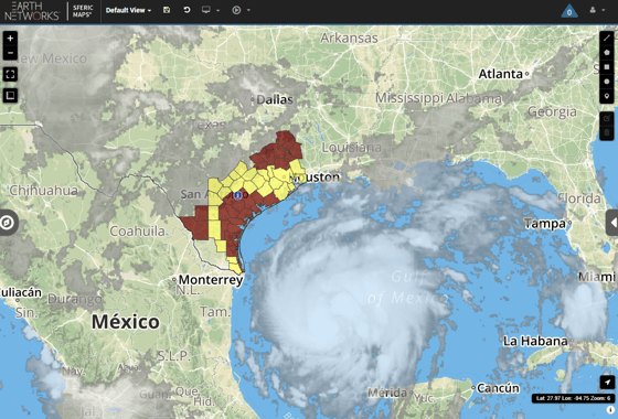
Here's our Facebook Live stream from headquarters. Earth Networks meteorologist Steve Prinzivalli talks about Hurricane Harvey with our severe weather tracker: Sferic Maps.
Stay Informed
Cities from Brownsville, Texas, to New Orleans will need to pay close attention to Harvey’s future progress. This checklist for hurricane preparedness should help.
Earth Networks meteorologists are watching the Harvey developments over the next several days and making updates as the forecast changes and becomes more refined. Check back often to discover new information.